Across the US, more than 40,000 people lose their lives in traffic crashes every year, with many more severely injured.
There is now widespread realization that this is unacceptable. No one should have their lives cut short just because they traveled somewhere.
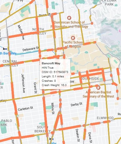
High Injury Networks (HIN) have emerged as a powerful tool to accomplish this vision. They allow planners and engineers to better target our efforts and resources.
What is a High Injury Network?
At its most basic, a High Injury Network (HIN) is a strategically identified subset of roadways within a specific jurisdiction where a disproportionately high number of severe traffic crashes—those resulting in serious injuries or fatalities—are concentrated.
Why is a HIN needed? Instead of spreading safety efforts thinly across an entire road network, identifying the HIN allows transportation professionals to laser-focus their attention and resources on the locations where they can have the greatest impact in preventing future tragedies.
Identifying High Injury Networks with easyHIN
Recognizing the critical importance of HIN identification, and understanding that the process can sometimes be complex and time-consuming, I developed easyHIN. My goal was to create a user-friendly tool that streamlines the process of visualizing and understanding HINs. Other, more powerful tools are available from the Volpe Center and from commercial vendors, but have a learning curve and/or a paid subscription.
With easyHIN, you can move beyond spreadsheets and manual GIS analyses. This tool empowers planners, engineers, and safety advocates to quickly gain actionable insights into their road network’s safety performance, enabling faster and more informed decision-making for safety improvements.
Identifying High Injury Networks with easyHIN is super simple:
- Load your crash data as you have it. It will ask you a few questions to get started.
- Grab the latest OpenStreetMap road network for your study area.
- Set parameters on how to segment the network and identify the HIN.
easyHIN will let you download GIS layers of the crashes and street network so that you can perform your own customization or mapping. My hope is that easyHIN helps you create HINs faster so you can focus on getting projects built.
Give it a try!
Grab your crash data (or this sample) and test out easyHIN today.
Or just drop me a note to talk about data-driven solutions to improve safety.